Next location: westbound eastbound
With a long day ahead of us, we leave Kayenta at sunup and head southwest on US 160, the rising sun casting our shadows several car lengths in front of us on the highway. We parallel Peabody Energy’s Black Mesa and Lake Powell Railroad that had carried coal to the Navajo Generating Station on Lake Powell until 2019. Bushes and weeds now grow in the tracks. “Adopt-a-highway” signs recognize local families’ departed loved ones instead of insurance agents or car dealers. The desert prairie is green, not the usual dormant yellow we’d expect in late August, but it’s been rainy this summer. We pass widely-scattered family compounds with six to ten houses. We turn right on AZ 98 and ten miles later we turn right again on Navajo Route 16 toward Navajo Mountain. As we approach the 37th parallel after 25 miles, we veer left on a dirt road labeled 161. In another ten miles we turn right on an unnamed dirt track at Haystack Rock. A mile later we pulled into Lyle Jones’ family compound.
A year ago we’d tried to locate the Rainbow Lodge trailhead by following USGS maps. Discouraged by Jeep tracks on the map that had disintegrated in a creek bed, we stopped at a house that seemed to be closest to the trailhead and knocked on the door. A man in his early 40s emerged, and with a knowing grin, assured us that we stood no chance of driving to the trailhead in our Subaru Outback. Given the lateness of the hour, I asked if he’d be willing to get us there when I came back in a year. He agreed. I took his name, Lyle Jones, and his phone number.
A year had elapsed, and we’d called Lyle to make sure the deal was still on. Now, I’d expected to be whisked up to the Rainbow Bridge trailhead in a high-clearance pickup capable of navigating the more remote roads of the Navajo Nation, but Lyle shouldered a small backpack, grabbed a plastic milk jug full of water and set off with us on foot, accompanied by two of his dogs. We walked an hour up the access road, no longer suitable for motorized vehicles, and arrived at the Rainbow Lodge trailhead, recently updated with a picnic table and an outhouse.
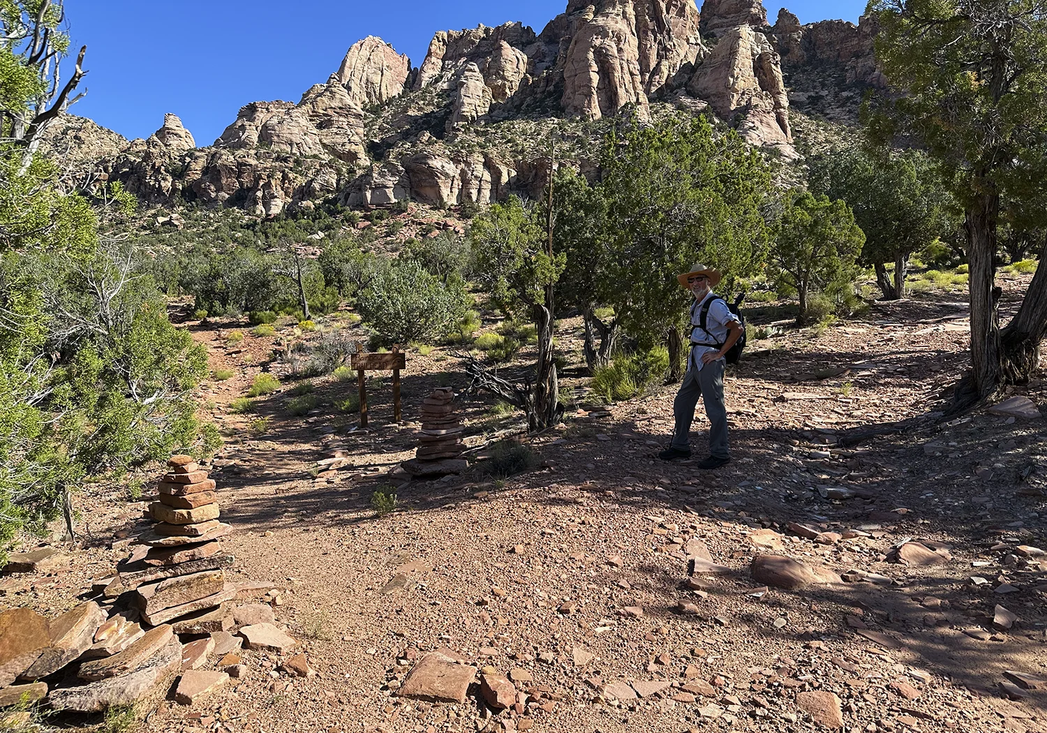
The Rainbow Bridge trail winds 16 miles north through barren benches and canyons to Rainbow Bridge National Monument on the south side of Lake Powell. Most hikers report seeing no one else on the trail, and that was our experience.
We’d expected Lyle to wave us goodbye, but he plowed on uphill, happy to share his stories to pass the time. His wife had died young; he has a couple of daughters in their early 20s living in the eastern part of the Navajo Nation, watched over by an aunt– he visits them three or four times a year. He’d gone to high school in Flagstaff; worked for a Navajo Chapter in the east side of the Nation, combining building maintenance with mentoring teenagers; installed air conditioners in stuffy Phoenix attics; worked for a mining company in Nevada; and now, at 43, he was home taking care of his invalid mother, his father having died a year ago.
His return to life in the shadow of Navajo Mountain might have included some regrets, but Lyle appeared happy to walk away from the hard drinking, hard working life he’d experienced around the southwest. He told stories of his growing respect for his nearby cousin whose knowledge of local flora and fauna was extensive. His father’s mother, Sylvia Manygoats, had possessed mastery of plant medicine. He regretted not learning more from her before she passed. Still, his fluency in Navajo gave him an entrée into acquiring local lore, and he found himself inclined to move in that direction.
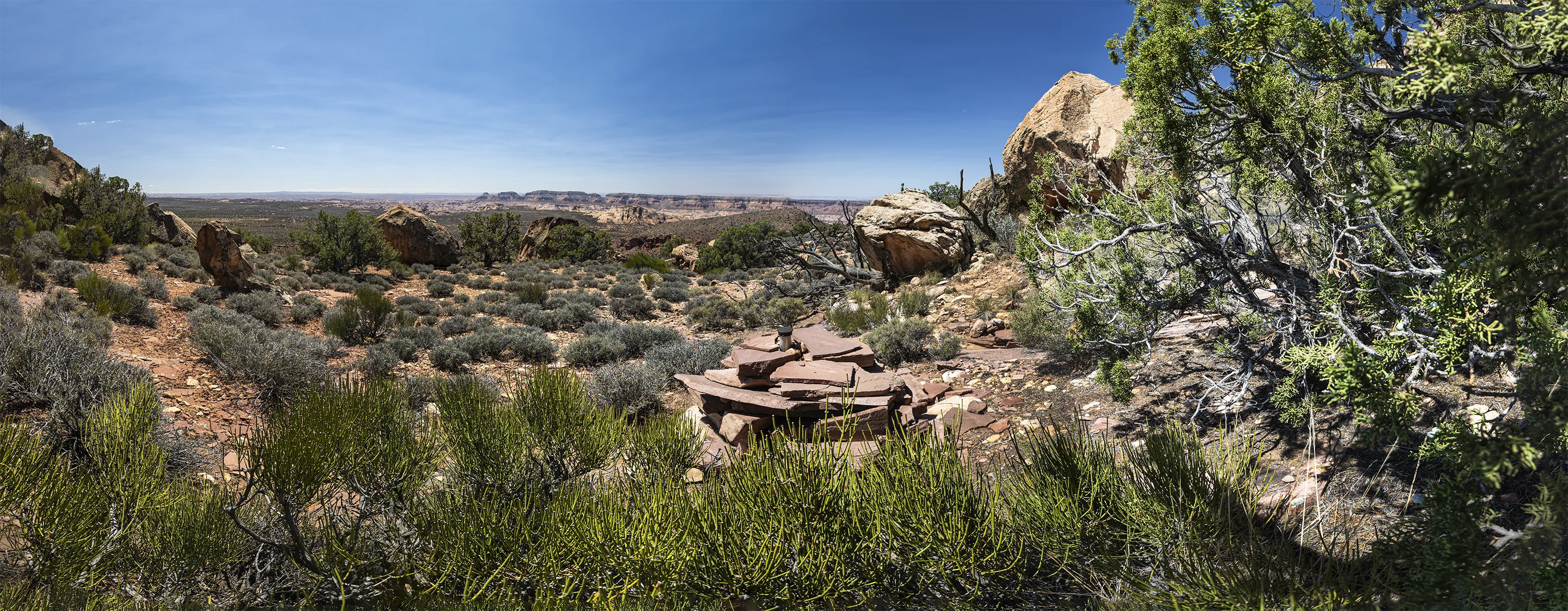
We moved up the trail, well-marked with cairns, in the silence of pure air and blazing sun, switch-backing across ravines and up steep slopes. When we reached an elevation of 6400 feet, we stopped to look west toward the “slickrock maze”1 of Kettle Country, where a remarkable story of defiance and resistance took place in 1863. The Navajo Nation had endured brutal suppression by the US Army under the leadership of Kit Carson; crops were destroyed, livestock killed, houses wrecked, and resisters killed who failed to submit (The ignominy embedded in this ethnic cleansing along with many other atrocities, such as the Sand Creek Massacre in southern Colorado a year later, remain untold stories for most Americans). Carson’s troops drove the Diné into submission: 8,000 of them, desperate and starving, set off under military escort on the Long March to Bosque Redondo 300 miles away in New Mexico. Incredibly, a tiny band of 17, led by 35-year-old Hoskininni, evaded Kit Carson’s ruthless troops and hid in the canyons of Kettle Country just south and west of our location on the Rainbow Bridge Trail. They thrived in this challenging landscape, growing crops, expanding their livestock herds, and weaving blankets. Hoskininni, who had been called “The Angry One” for demanding discipline and commitment from his tiny band, gained a new nickname when the survivors of the Long March returned to the homeland in 1868. His band came out of hiding and gave corn, sheep, wool, and skins from the vast store he had accumulated. Out of awe and gratitude, the refugees bestowed on Hoskininni a second nickname—“The Generous One.”
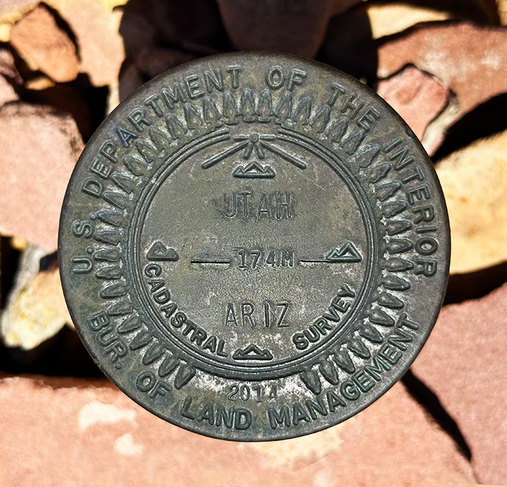
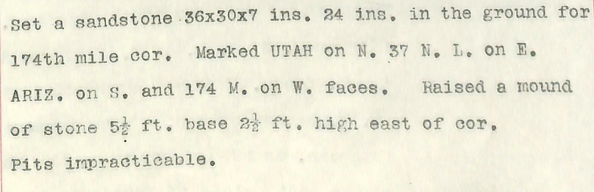
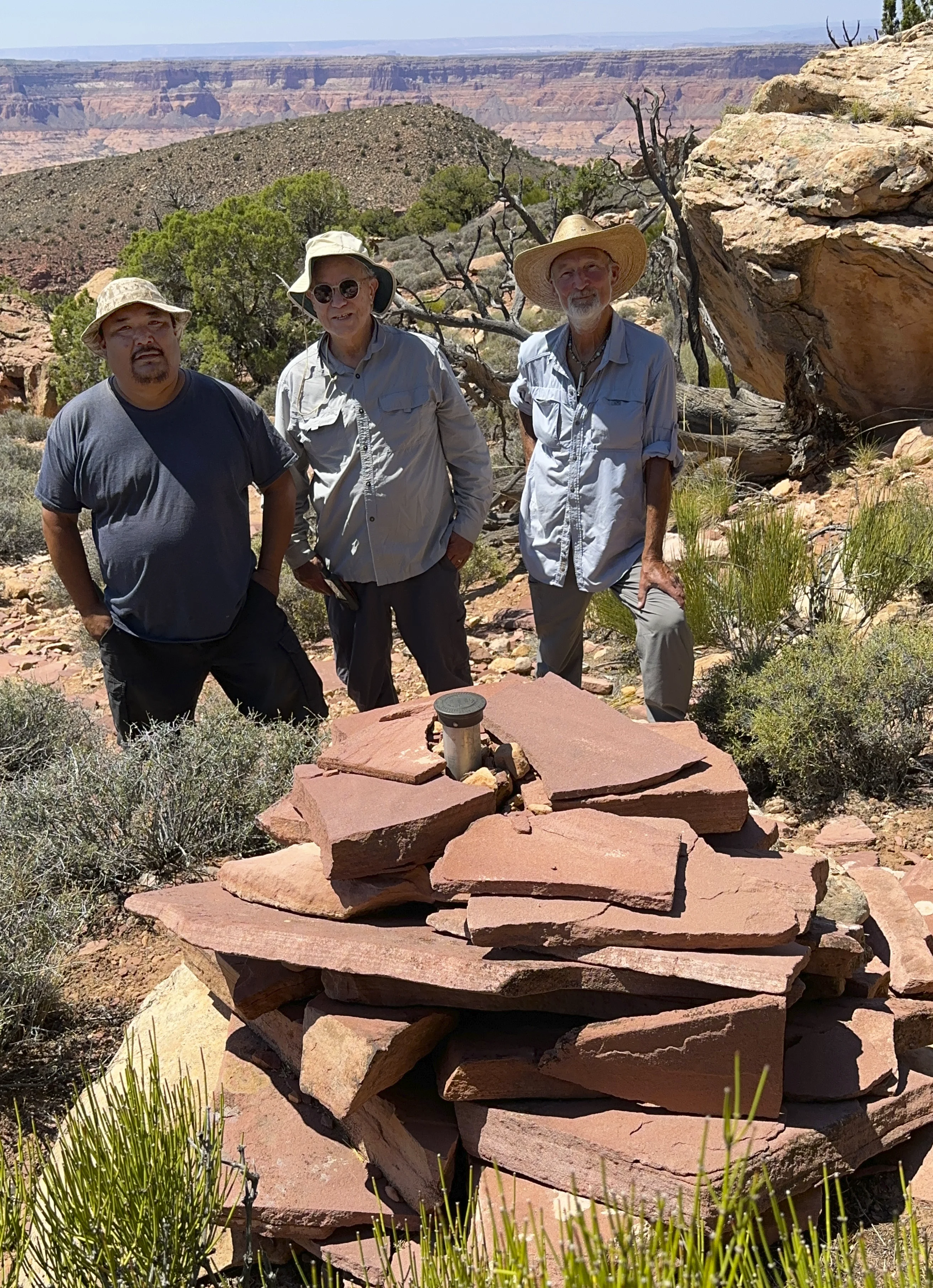
There were no state border markers on the Rainbow Bridge trail; even though he’d roamed this vast landscape since childhood, Lyle hadn’t thought about borders: the physical state boundary has little relevance to members of the Nation. From a close reading of the USGS maps we figured that when we reached an elevation of 6,400 ft. we should head off the trail and hike southeasterly through the high desert, climbing the shoulder of Navajo Mountain to find the survey marker. When the GPS eventually indicated we were in the survey marker’s neighborhood, the three of us prowled around the mesquite and sandstone, finally locating the mound of stone piled around the Mile 174 marker. Howard Carpenter’s survey team had arrived here May 29, 1901 and had placed a sandstone post to mark the corner. In 2014 the marker was updated; we saw no evidence of Carpenter’s original marker.
The views were long and the air was clear, but we were hiking in a 93˚ convection oven of a day. On the way out Lyle, having guessed that our four liters of water would prove insufficient, shared his gallon of water. The trip had covered new ground for him as well– he was surprised to come across Carpenter’s updated monument. We were grateful for his company and his familiarity with the landscape. We were fortunate to spend a day walking 8 1/2 miles in his vast back yard.
——————————————————————————
Footnote
1 David Roberts, “Catch Me If You Can” (Backpacker Magazine, May 2015) https://www.backpacker.com/stories/catch-me-if-you-can/