Next: Eastbound
Here, on the Nevada line, we begin our trip east to Missouri along the 37th parallel. Let’s start with a thumbnail orientation: on paper, the 37th parallel was established in the Compromise of 1850 as the border line separating Utah Territory from New Mexico; Arizona as its own territory wasn’t invented until 1863. And for another 38 years no one thought it necessary to drive stakes in the ground to make the border between Arizona Territory and Utah real. Now, the eastern end of the line had already been surveyed from the Missouri border starting in 1857. By 1868 the line had reached west to Four Corners, but the Utah-Arizona line remained theoretical; a border, after all, to extrapolate from Ambrose Bierce’s The Devil’s Dictionary, is “…an imaginary line… separating the imaginary rights of one [state] from the imaginary rights of the other.” To transfer the line from paper to the desert, Howard B. Carpenter was hired in 1901 to complete the missing segment of the 1209-mile straight line between Nevada and Missouri.
On March 20, 1901, Carpenter, along with an assistant astronomer, a transitman, 4 chainmen, 2 moundmen, an axeman, a rodman, and 2 flagmen all swore to execute their jobs faithfully. His logistics team, no oaths required, included a cook, teamsters, packers, a Paiute guide and a Navajo interpreter. A week later, for three nights in late March, Carpenter made astronomical observations to determine his latitude. Then, after considerable tedium prowling the desert searching for 30-year-old markers that had rotted or vanished, he verified the Nevada border and zeroed in on the location to plant his red sandstone marker known as the Initial Monument, which ended up a mere 74 feet north of the 37th parallel as GPS systems define it now.
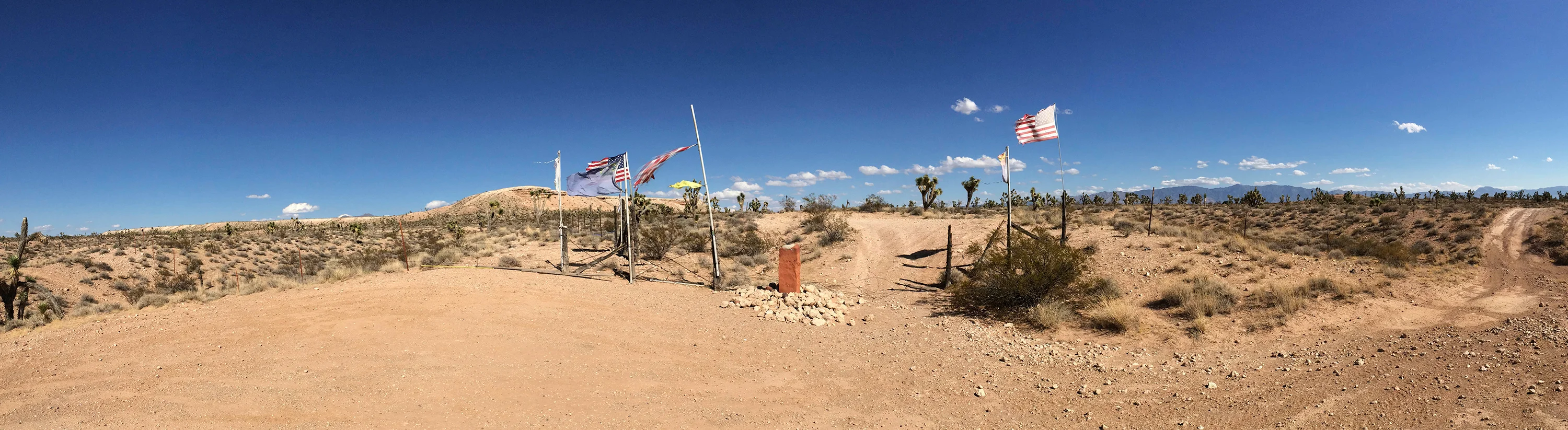
When I first visited this spot back in 2015, I’d followed the 50-year-old USGS instructions that recommended following dusty tracks north from Beaver Dam, Arizona to a “bladed crossroads” in the middle of desert landscape called Terry Benches. From there I’d taken a wrong turn and ended up walking the final mile to the Tri-State Corner. When I arrived there was no mistaking the location: not only was Carpenter’s red sandstone marker there– although with fewer rocks buttressing it than he’d placed in 1901– but it was flanked by a number of tattered flags wired to the fence along the Nevada line– a kind of anarchic American fencepost patriotism that snapped in the wind like Bhutanese prayer flags.
Now, here’s how we found the Initial Monument in 2023:
On the return trip to the Initial Monument, we’d just come from Las Vegas, holy ground for American simulacra. There you can visit casinos that evoke New York, ancient Rome, or Egypt, with elaborate shows that run forever, pretending they’re not actually in the desiccating desert, hoping Lake Mead’s water level remains above dead pool.
Happy to escape the pretense, we roll east on I-15 to Beaver Dam, Arizona, and head out early into the desert. The Tri-State corner is less than ten miles as the red-tailed hawk flies, but it took a couple of hours, even with good signage. We found the bladed crossroads described 50 years ago by the USGS and headed ENE. The deeply-rutted track rose to a crest obscuring a ski jump into a gully suitable only for dune buggies; we decided to walk the last mile, following the track of a sidewinder in the fine dust. Surveyor Carpenter described the landscape in 1901: “Vegetation scanty, grass, greasewood, and a few yucca dragonis or Spanish bayonet trees.” What we saw: not yucca aloifolia, the Spanish bayonet tree, but yucca brevifolia, the Joshua tree. Carpenter assessed the soil as “4th rate,” meaning, for starters, that the landscape surface was difficult for surveyors. Our sidewinder trail ended at a broad, dusty parking lot in front of a civic installation that evokes veterans’ memorials in many a midsize town across America.
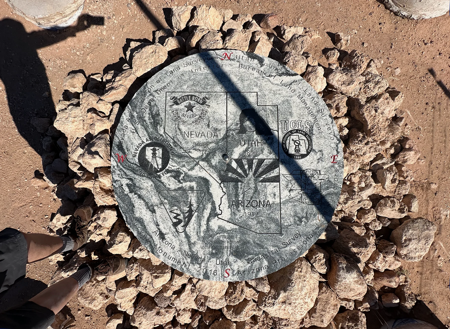
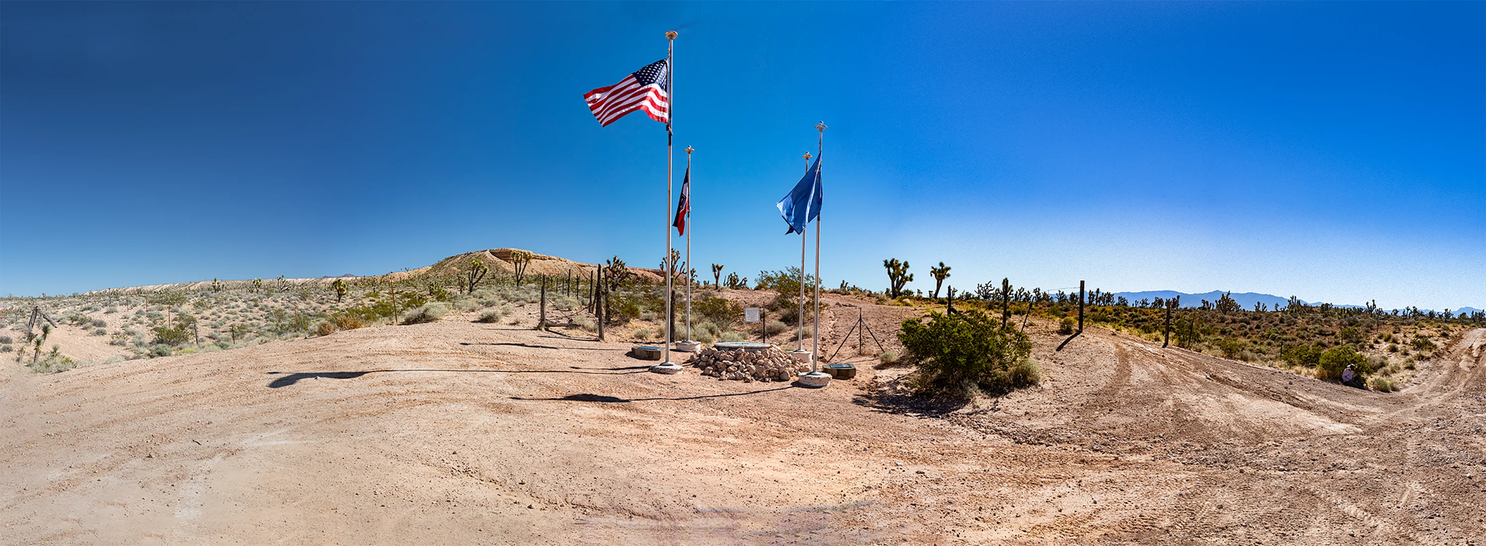
Four flagpoles, topped with solar-powered lights, flank a circular coffee table-sized granite disk at the center of which sits a metallic button indicating the actual survey mark. The coffee table features a map of the states’ borders along with state symbols (Utah’s Delicate Arch, Nevada’s “Battle Born” slogan, and Arizona’s radiating sunbeams), imprimaturs of the professional surveyor associations of the three states along with the Bureau of Land Management, and acknowledgement of a granite supplier and a gravestone maker in nearby St. George, Utah. The original surveyor, Howard Carpenter, is recognized on a nearby plaque.
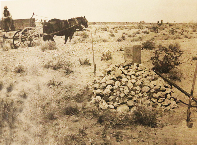
Carpenter’s monument in 1901. Photograph from Carpenter’s survey notes, archived in Bureau of Land Management, Cadastral & Indian Surveys Branch, Phoenix, AZ