Next Location westbound eastbound
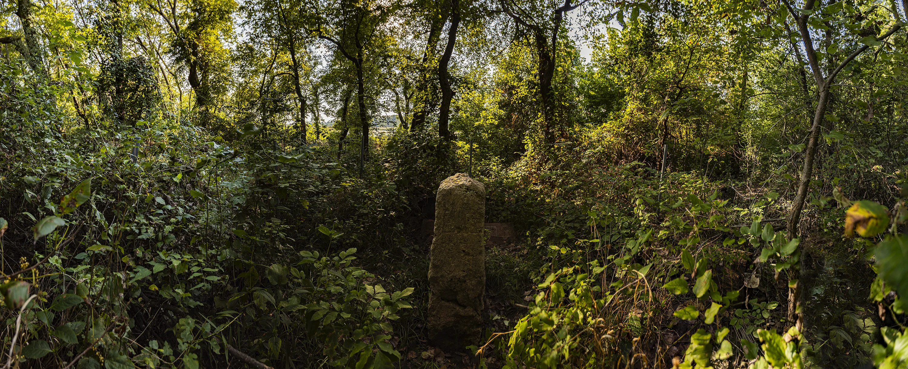
Armed with GPS coordinates, my wife Nancy and I walk precisely west at 37˚ North Latitude toward the Arkansas River, on the northern boundary of the Kaw Nation. We push through the detritus of a vigorous springtime flood to the river’s edge and backtrack, climbing through tangled thorny vines, finally spotting a four foot tall limestone bollard, a standing stone, perhaps.1 There, surrounded by the flood debris and tangled vines, it has the gravitas of an ancient relic, the look of something sacred, lost in an abandoned garden, like a monument to honor a town’s World War II dead in a traffic circle: a cenotaph.
What elevates this survey marker to the status of a cenotaph? A cenotaph is an empty grave, tomb or a monument erected in honor of a person or group of people whose remains are elsewhere. In the past century cenotaphs mostly honored fallen soldiers, e.g. Maya Lin’s Vietnam Veterans Memorial in Washington. Cenotaphs memorializing heroes date back to Roman and Mughal times. But this bollard stands as a mnemonic not to individuals lost in war but rather to a lost era, when Indigenous peoples roamed and lived freely in a vast land without fences or borders. It’s an ironic memorial: it’s not just a stake in the ground that established a line of demarcation for ethnic cleansing, separating Kansas from the Indian Territory, where Indigenous peoples who were pushed out of lands now occupied by western settlers were sequestered. Now we can see it as a reminder to honor the land itself, its original inhabitants, and the dignity of its originally reluctant immigrants.
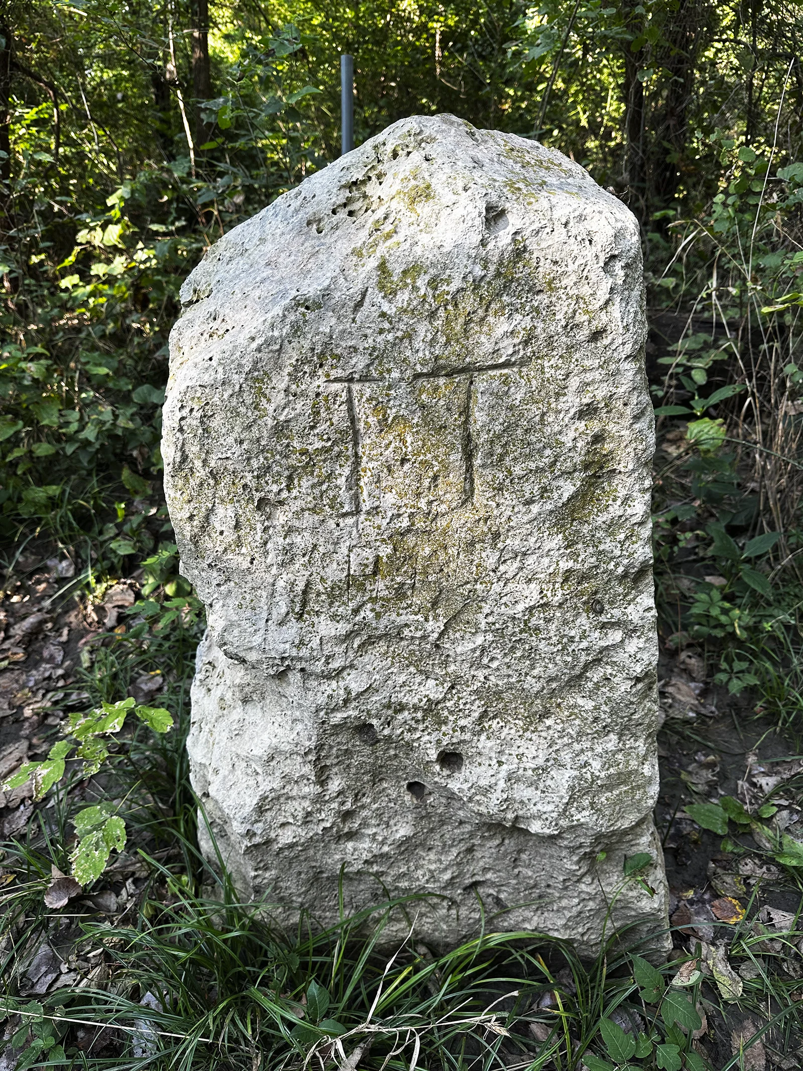
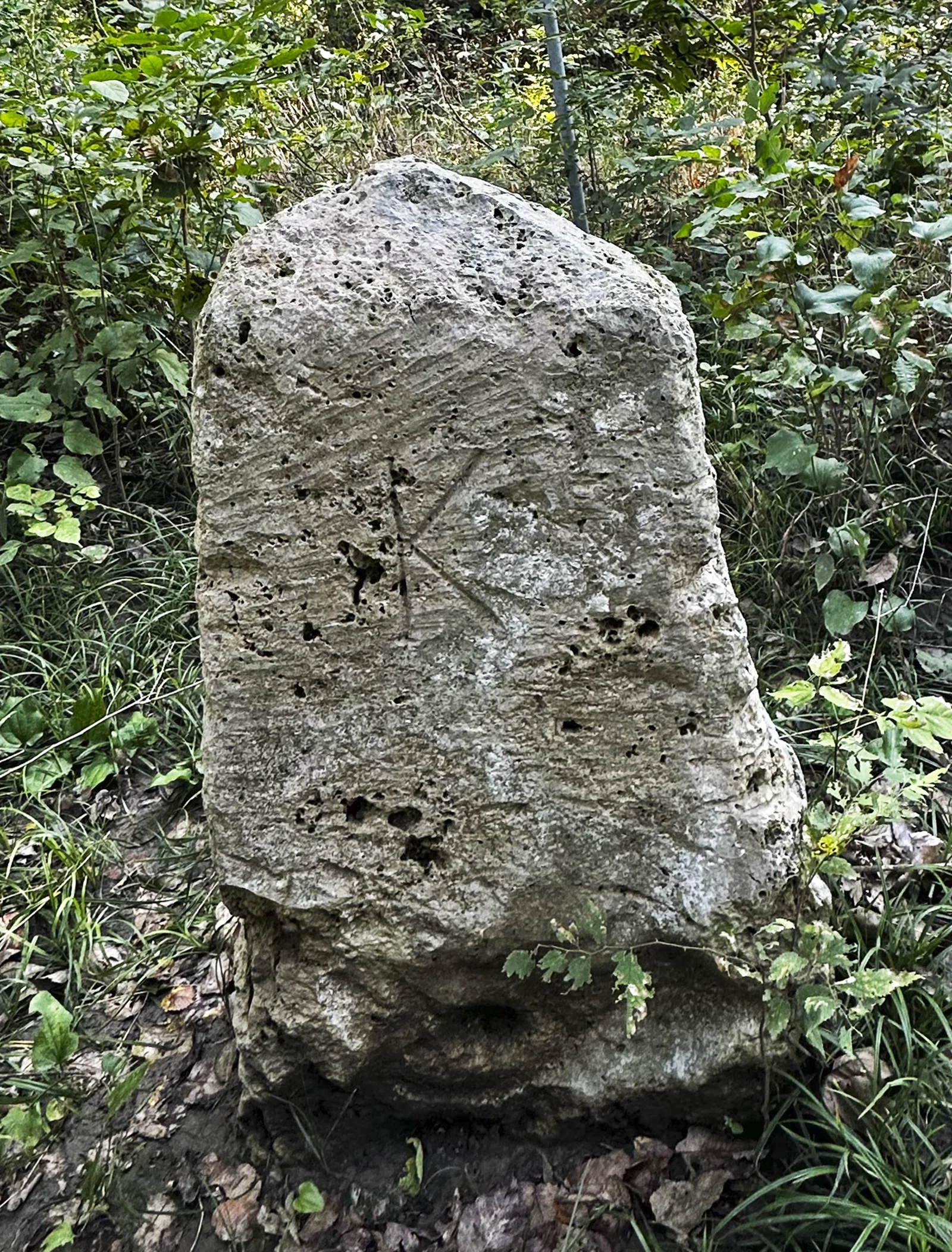
Still, it’s only a survey marker. “K” for Kansas is chiseled on the north side and “IT” for Indian Territory on the south. It was the western terminus of an 1871 survey that ran from the Neosho River, 86 miles and 18 chains east of here. Surveyor John E. Chandler was charged with establishing the North Boundary of the Cherokee Nation between the Neosho and Arkansas Rivers, but the survey marker indicates only IT for Indian Territory, as though a more specific label was unnecessary– or too laborious to chisel. Chandler’s 1871 line re-established the boundary, originally surveyed in 1857, between Kansas and Indian Territory. The first survey team, accompanied by four companies of cavalry, two companies of infantry and two mountain howitzers, crossed the Neosho and proceeded westward, navigating solely by compass, since there were no settlers and no roads to provide a sense of direction, as Eugene Bandel pointed out. Bandel, a Russian immigrant who’d enlisted as a private in the U.S. Army, was an infantryman assigned to the expedition and kept a diary. His entry for the first day west of the Neosho, June 21, 1857, described the landscape: “The country through which we came today is exceedingly beautiful. Nothing to remind the men of being on the prairies, the hills are frequently wooded with the best kind of timber such as walnut, hickory, and oak. All ravines are thickly timbered. Grass very rich and high.”2 Indian Territory appeared Edenic.
But even if the landscape was felicitous, what happened next, after decades of warfare across the plains, was not. In the 1870s European-Americans finally asserted their hegemony in the western territories. To open up the West for settlement, the U.S. Army corralled the wide-ranging high plains people into Indian Territory, where they joined southeastern and Great Lakes people who had already been force-marched there from their homelands. Until this time, the United States had negotiated with Indigenous groups as sovereign nations, but in 1871 the Indian Appropriations Act stripped away any illusions of deference. Independence disappeared: Indigenous peoples effectively became wards of the state and were subjected to neglectful guardianship.
A year later, in 1872, the slaughter of bison in their millions across the high plains by commercial and recreational hunters reached its peak. For centuries the nomadic peoples of the plains had based their lives and cultures on the bison (also called buffalo), and now they were forced into a largely bison-free zone. Even though the Medicine Lodge treaties of 1867 gave them right to hunt in the plains, they would be forced to stop hunting when the bison were gone, an eventuality not lost on the U.S. army. “In 1875, General Phil Sheridan…allegedly said, ‘Let them kill, skin, and sell, until the buffalo is exterminated. It is the only way to bring a lasting peace and allow civilization to advance.’”3
1874 saw the introduction of barbed wire. Suddenly the prairies could be quickly transformed into manageable range land. International speculators rushed west; farmers from the east arrived by railroad with dreams of homesteading (but often with insufficient capital). Across the plains Indigenous resistance weakened. Historian Pekka Hämäläinen declared that by 1877 the war was over: intrepid Native peoples were finally defeated, Hämäläinen posits, not by brilliant military tactics but by railroads, repeating carbines, and post offices (through which military intelligence was disseminated).4
A decade later, in 1887, the Dawes Act delivered a crushing blow to all reservation Natives except the so-called Five Civilized Tribes (Cherokee, Chickasaw, Choctaw, Muscogee, and Seminoles) who had arrived in Indian Territory via the Trail of Tears5. A few other groups– the Seneca in New York, in particular, fiercely fought off the Dawes Act and remained largely unaffected. But Dawes succeeded in undermining Indigenous groups by requiring land to be allocated to individuals and families instead of remaining under collective control of the Tribe. Carl Schurz, Interior Secretary in the 1870s, argued, “‘When the Indians are individual owners of real property, their tribal cohesion will necessarily relax, and gradually disappear. They will have advanced an immense step in the direction of the white man’s way.’”5 Except for the word “advanced,” he was vindicated by events. Dawes was a major assault on Indigenous cultures, most of which held that one could no more own land than ocean. Native relationships with land were defined not by boundaries but by knowledge of place. On most reservations, significant acreage was left over after allocations were made, and this land was sold to American settlers. A large area of unassigned land was quickly seized by 50,000 Sooners rushing in from the Kansas border on April 22, 1889. In the end, in 1934 when the Dawes Act was repealed, land under Native control had shrunk from 138 million acres in 1887 to 48 million acres.
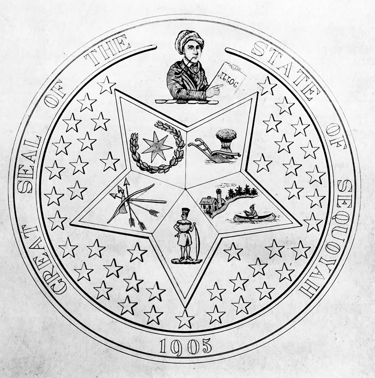
But the spirit of Native peoples in the Territory persisted. In 1905 the leaders of the Five Civilized Tribes sought to form their own state, to be named Sequoyah (the California trees were named for him too: a Cherokee polymath known for creating the first written language north of Mexico). The Five Civilized Tribes held a constitutional convention, completing a constitution and a governmental organization plan, but President Theodore Roosevelt and Congress turned down the Sequoyah proposal. Oklahoma became a state two years later, absorbing Indian Territory, although remnants of tribal sovereignty persist to this day.
Across the Native world in eastern Oklahoma the Indigenous Nations remain alive, struggling with the competing desires to maintain language, culture, and tradition while finding ways to survive economically. Treaty language in 1867 had described Indian Territory as designated for “the absolute and undisturbed use” for Indigenous peoples, but that illusion has long since become diluted. Carl Schurz probably didn’t expect the tribes to survive 150 years, but they’re still finding their way in the territory that is no longer theirs alone.
In the end the Kansas-Indian Territory stone no longer marks a contemporary political division– the Indian Territory no longer exists. Even though the stone sits on or near the Oklahoma-Kansas line, cadastral surveyors now rely on GPS for declaring boundaries. The marker’s role has shifted: now it serves as a cenotaph, to remember both the vast 19th century ethnic cleansing that reorganized western North America and to honor the peoples who have called this land home.
_______________________________________________________________________________
End Notes
1 Standing stones are usually associated with neolithic times in Europe, but some exist in North America. Nee Yah Kah Tah Kee (“Standing Stone” in Cherokee) was the name of a stone placed in Tennessee’s Cumberland Plateau to mark hunting grounds shared by neighboring Indigenous groups.
2 Eugene Bandel. Diary of Eugene Bandel, 5/16/1857 – 11/14/1857. Original manuscript from California State Library, Sacramento
3 Carolyn Merchant, American Environmental History (NY: Columbia Univ. Press, 2007), p.20 quoted in ‘Kill Every Buffalo You Can! Every Buffalo Dead Is an Indian Gone’ By J. Weston Phippen, The Atlantic 5/13/2016,(https://www.theatlantic.com/national/archive/2016/05/the-buffalo-killers/482349/)
4 Hämäläinen, Pekka, Indigenous Continent: The Epic Contest for North America. (New York: Liveright Publishing Corp. and London: W.W. Norton, 2022), p. 450
5 The Trail of Tears: Starting in 1838, 46,000 Indigenous people were forced to walk from the southeast states to Indian Territory, with thousands dying from exposure and hunger along the way. By late 1840s, 100,000 Native people had been moved to Indian Territory. Start here for further reading: Roxanne Dunbar-Ortiz, An Indigenous Peoples’ History of the United States. (Boston: Beacon Press, 2014)
6 Banner, Stuart. How the Indians Lost Their Land: Law and Power on the Frontier. (Cambridge, Mass. and London, England: The Belknap Press of Harvard University Press, 2005) p. 268
7 “State Seal Incorporates Territory, 5 Tribes’ Seals,” The Oklahoman, November 13, 1982. https://www.oklahoman.com/story/news/1982/11/13/state-seal-incorporates-territory-5-tribes-seals/62867072007/