Next location: westbound eastbound
I respectfully acknowledge that the following story involves the traditional, ancestral lands of the Osage Nation. The process of encountering the land we explored was a way of honoring and expressing gratitude for the ancestral Osage people who were on this land before us.
This whole project originated in a love of maps. The US Geological Survey publishes detailed topographic maps in several scales, including 1:24,000, or 7 1/2 minutes of longitude by 7 1/2 minutes of latitude. Along the 37th parallel between Nevada and Missouri there are 156 maps south of 37 degrees and another 156 maps north of the parallel, with the state borders of Utah and Arizona, Colorado and New Mexico, Colorado and Oklahoma, and Kansas and Oklahoma appearing sometimes on the northern map and sometimes on the southern depending on errors made by the original surveyors.
Late in June of 1857, Surveyor J. E. Weysse and astronomer Hugh Campbell, responsible for the initial survey of the southern border of Kansas, weren’t far off when they got to the Flint Hills, in what is now Oklahoma’s Osage County. They marked the border at what’s now understood as 36˚ 59′ 56.88237” (N) or just over 3 seconds of latitude or 316 feet south of the true line. Here’s how their legacy bears out 166 years later:
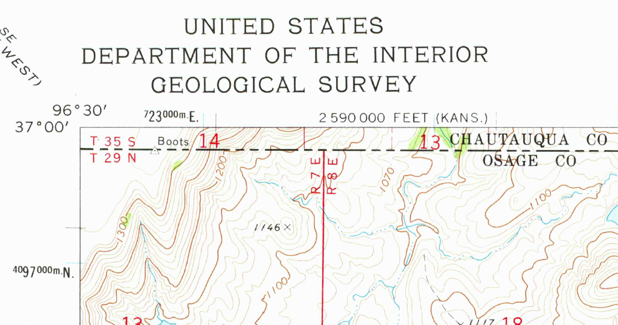
The Flint Hills in Osage County Oklahoma are traced in several USGS maps, one of them titled Pearsonia NW. In the extreme upper left corner of this map– the 1973 version– you’ll see a survey marker in 7-point type on the Kansas-Oklahoma line named “Boots.” The marker is described by the Coast and Geodetic Survey as placed in 1962 on the northeast part of a large ridge, which is pasture land, owned by K.S. Adams, nine miles east of Grainola, OK.
The marker is not shown on the 2018 version of the same map. Was the survey marker still there in 2023? Now, even though the early surveyors’ notes documented the placement of survey markers (or monuments, as the surveyors call them) every mile for the 1209 miles between Missouri and Nevada along the 37th parallel, few of them survive today. And few of them have idiosyncratic names like ‘Boots.’ I was determined to find it.
The map west of Pearsonia NW, called Foraker North, showed us how to get to Boots. Graded county roads took us to rough ranch tracks that threaded through the tallgrass prairie up to the Kansas-Oklahoma line. We turned off County Road 4551 where a weatherbeaten sign pointed to Sooner Cattle Company, a series of barns and houses and an aging water tower. We knocked on every door. A couple of horses in a paddock and a mild-mannered dog seemed to appreciate our arrival, but no one was around. Now, even though we’d been here a couple of years ago and received permission to drive out on the ranch, it seemed appropriate to ask again. Out of luck, we headed out to the county road where we flagged down an incoming construction vehicle. The driver gave us the name and phone number of the ranch manager. After a long struggle with sketchy mobile service I connected with Dale Richardson who kindly offered to take us up to the line when we passed through the area on our way east, two weeks later.
We arrived at the ranch at 7:30 in the morning; Dale texted that he was taking care of some cattle and would meet us as soon as we could.
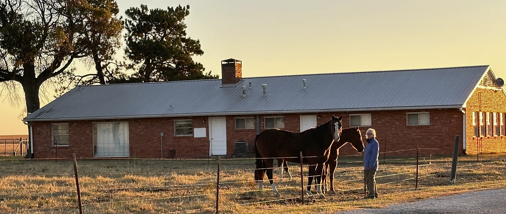
About an hour later he arrived, unhitched a cattle trailer, and invited us to hop into his truck. We made our way north through immense bluestem pastures, a classic tallgrass prairie, opening and closing gates until the road disappeared into the three-foot grass, mostly big bluestem, the signature grass species of the Flint Hills.
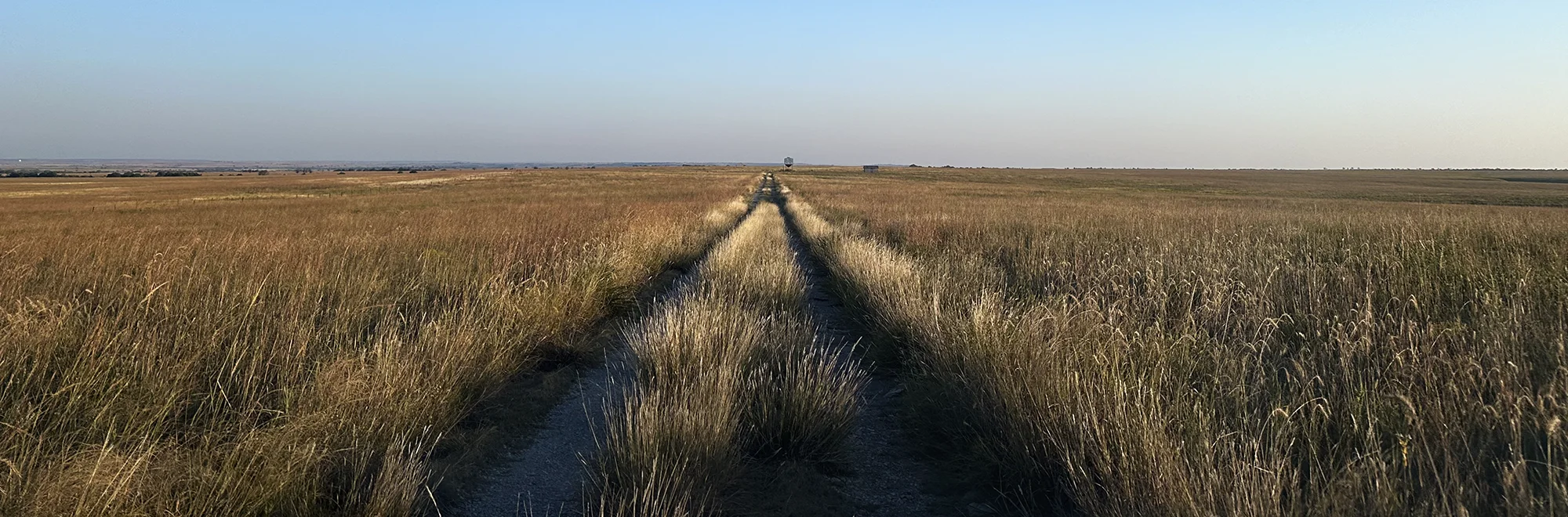
The truck galumphed slowly through the field while Dale told us about ranch management, prairie stewardship, preparing fodder and grazing for winter. Yearling cattle, raised in Florida, are brought here to grow for nine months before heading for the feedlot. Dale and his company are mulling expansion into a cow-calf operation. We got the impression that decisions about moving cattle from one pasture to another, about cutting hay, about managing cyanobacteria in farm ponds, repairing fence, implementing prescribed burns to revitalize the prairie, or any of thousands of other ranch tasks are all handled with cautious and thoughtful deliberation. Dale clearly evinced a commitment to his role as a prairie steward. He also told stories of encountering prairie chickens and other wild local residents of the area.
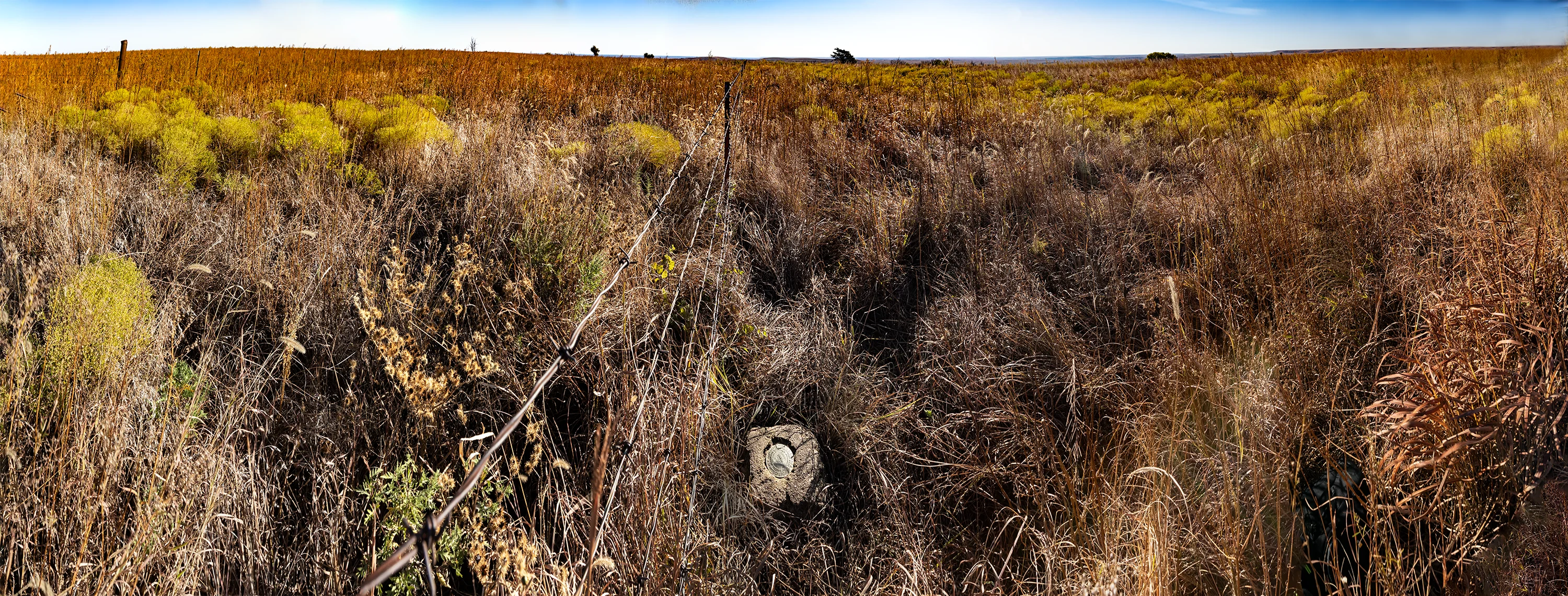
As my GPS device zeroed in on a latitude of 36˚ 59′ 56.88237″ we climbed out of the truck and walked up to a fence line that closely matched the latitude; as we walked eastward toward the proper longitude, Dale kicked at a clump of dead grass, exposing the monument. He’d found Boots at 36˚ 59′ 57.2208” N, a third of a second farther north than the official USGS measurement, according to the Iridium Network, with a longitude of 96˚ 29′ 47.0256” W.
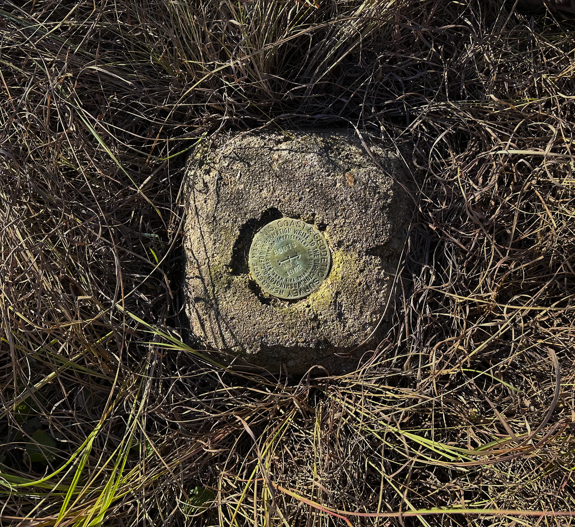
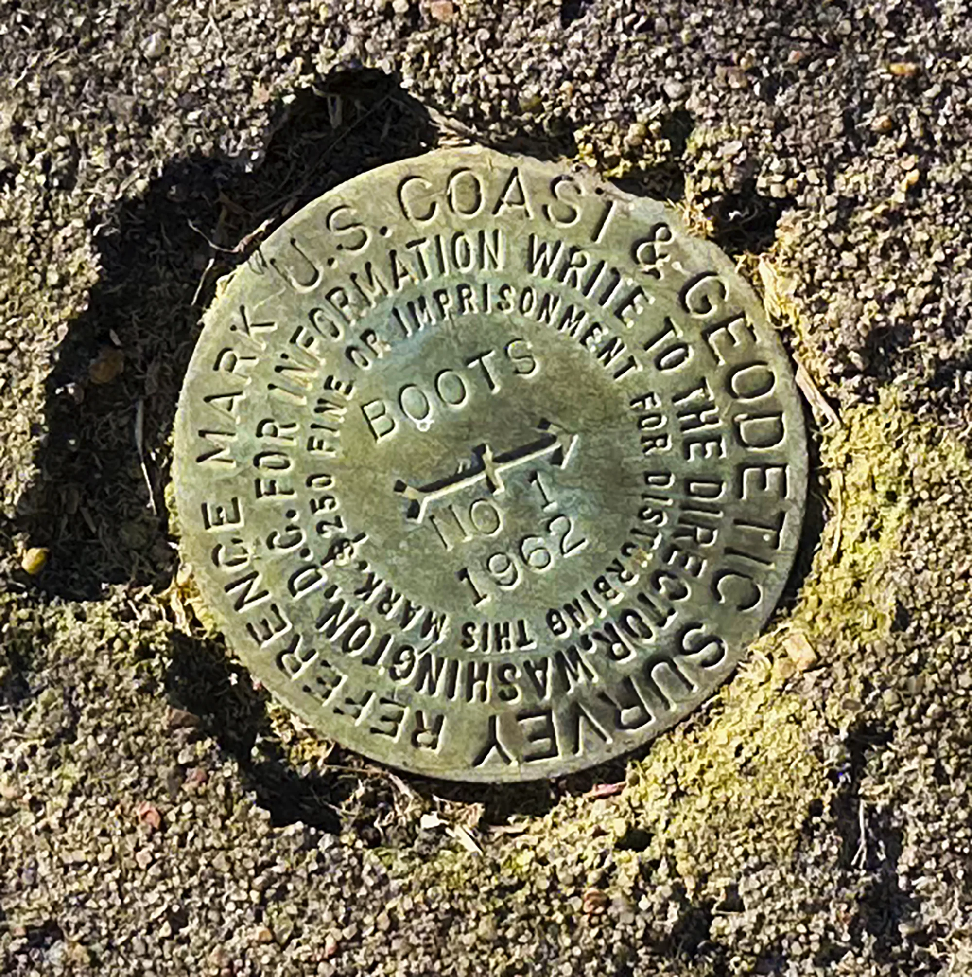
How did this survey monument come to be named Boots? As the USGS declared in 1962, the pastureland was owned at the time by Kenneth Adams who had been president of Phillips Petroleum. Wikipedia reports that In 1902, his father’s family provided room and board to many families affected by a flood, including co-workers of Adams’s father, a Rock Island Railroad engineer. “One of the male guests noticed that Kenneth had a pair of boots he wore even to bed. The man began calling him ‘Boots’. From then on, Kenneth Adams adopted ‘Boots’ as his nickname.”1 Boots died in 1975. Twenty-four years later, his heirs sold the ranchland of “at least 50,000 acres in Osage County and southern Kansas” to a Utah corporation– Deseret Ranches– owned by the Mormon Church. Deseret Ranches, one of the nation’s largest landowners, also owns over 300,000 acres in Florida and has holdings in Montana and elsewhere.
It’s a little difficult to stand at the Boots monument and focus on the economic power of the LDS Church and their multi-state cattle operation or on the history of cadastral surveys here. Instead, the visitor will steep in the tallgrass silence under the clear October sky, far away from highway noise or 21st century distractions. William Least Heat-Moon wrote about the Flint Hills in Chase County, Kansas, due north of here, in PrairyErth2. He, too, was spellbound by the grassland, which survived relatively untouched because the soil was too rocky to plough. Unlike other areas along the 37th parallel that have been severely damaged by overgrazing and drought, the grand sweep of tallgrass prairie in Osage County’s Flint Hills survives and thrives.
Footnote
1. Hitchcock, Doug (August 1983). The KU-Bartlesville connection. Lawrence Journal-World. Retrieved June 5, 2013.
2. Heat-Moon, William Least, PrairyErth. (Boston: Houghton Mifflin, 1991)