Next Location: westbound eastbound
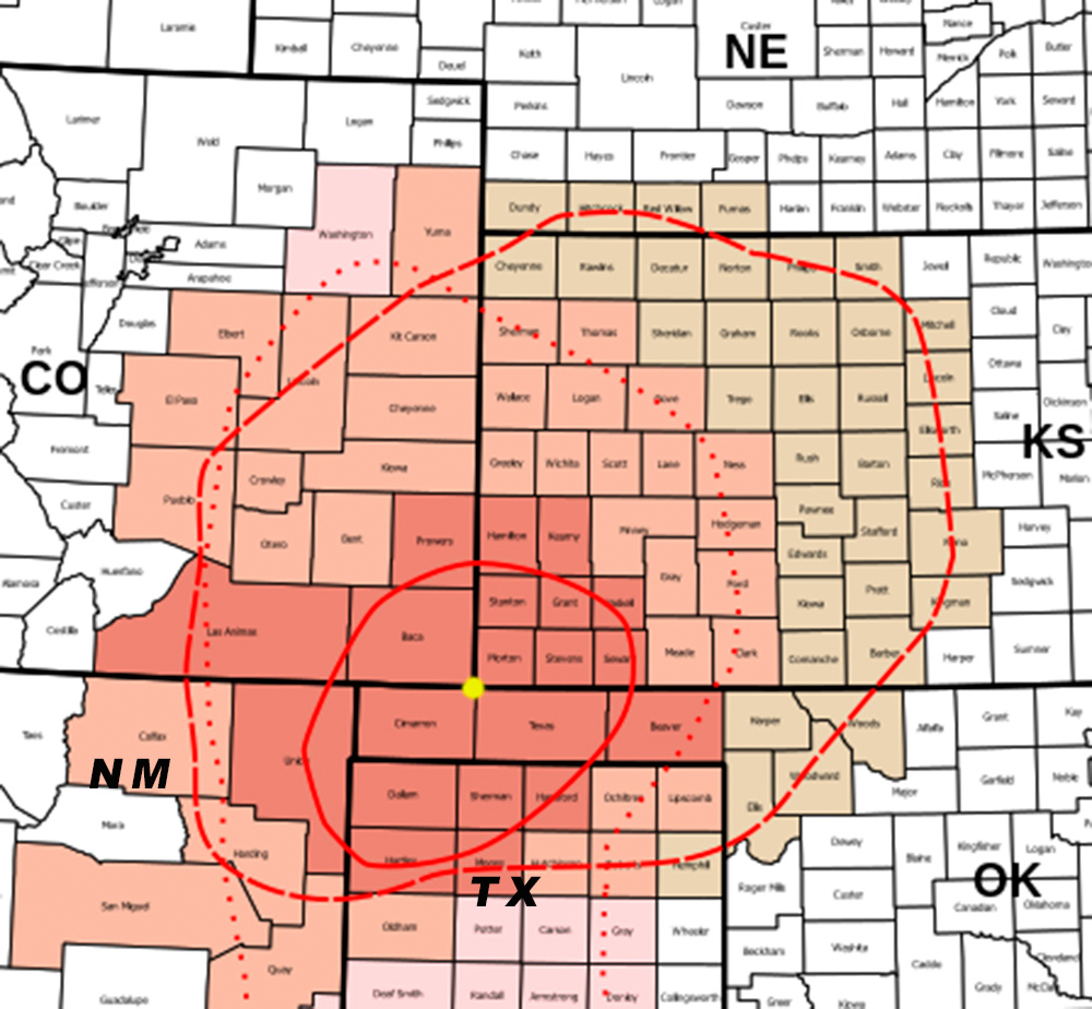
The story about this tri-state corner requires cartographic orientation because, although it’s ground zero for one of the nation’s most intense meteorological events from 80-odd years ago, odds are you haven’t been here before, and the immense landscape of the Oklahoma panhandle and its surrounding counties lacks any prominent features you might have heard about. Where to start? How about Elkhart, Kansas, with a population of 1,888, the largest town in the region, which sits just eight miles from the tri-state corner where Kansas meets Oklahoma and Colorado. Let’s start in Elkhart.
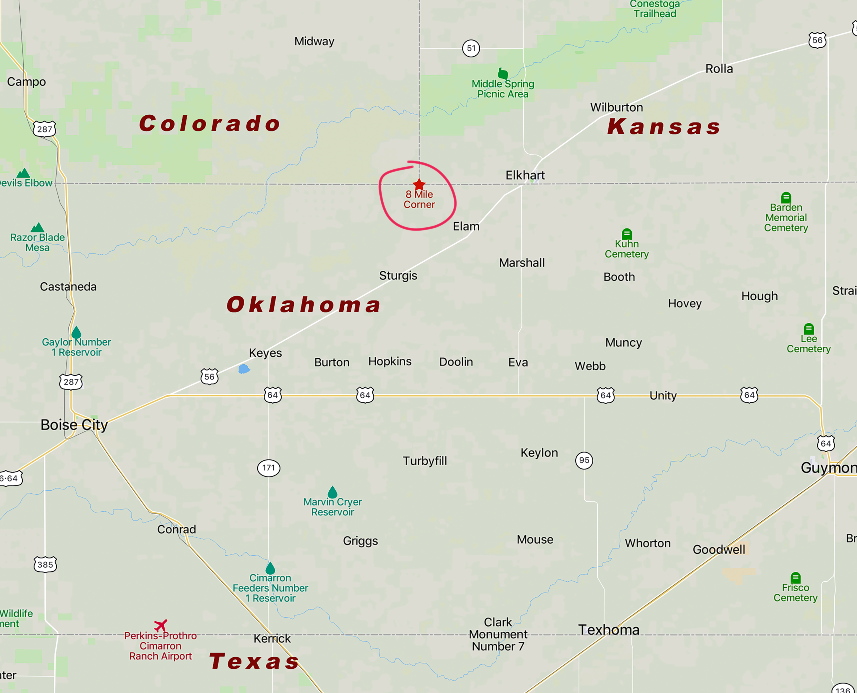
From the middle of town, head southwest on US 56 and turn right on Boulevard A, which turns into Country Road A and passes a road improbably named Michigan Highway 1. In another mile and three-quarters you’ll come across an incongruous manhole cover in the middle of Country Road A– manhole covers are not usually found on gravel roads on the high plains. Hidden below the manhole cover is the official survey marker that indicates the conjunction of Kansas, Oklahoma, and Colorado. The cover was decorated by a welder to indicate the adjoining states and the dates they were admitted to the Union.
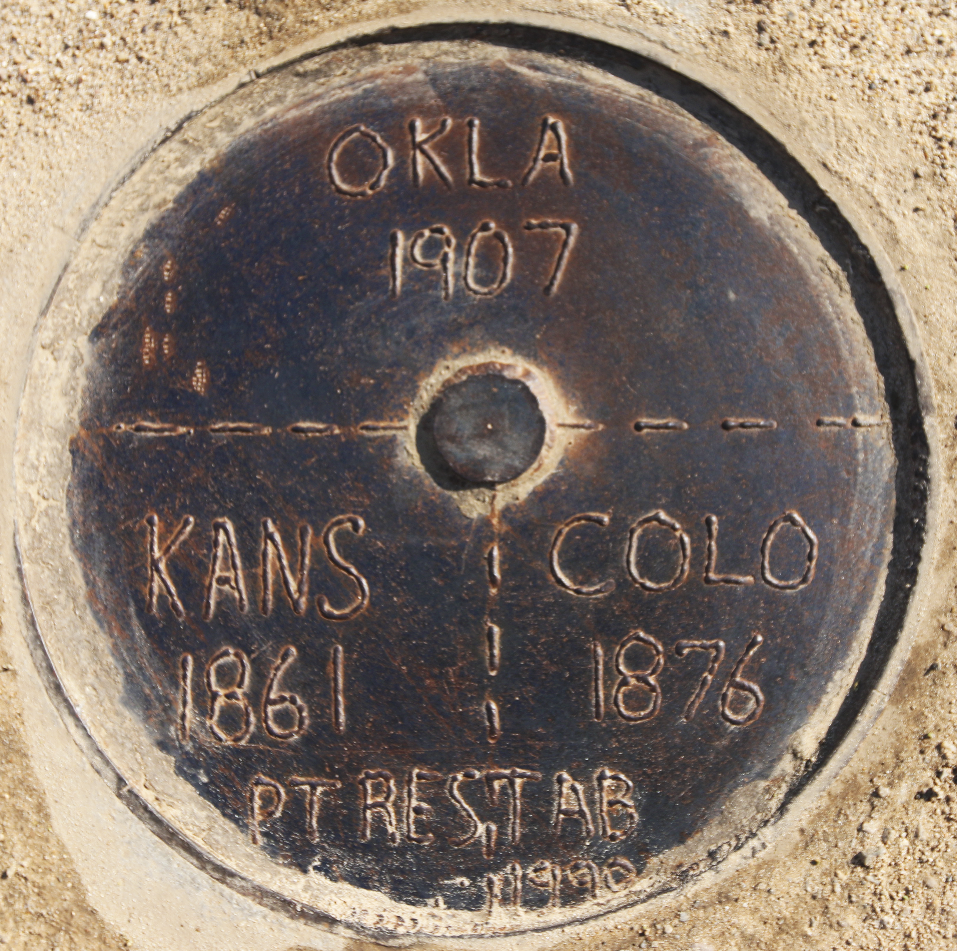
This dusty road on the shortgrass prairie is a curious place for a history lesson: Kansas became a state on January 28, 1861, two days after the sixth southern state seceded before the Civil War, breaking the north-south deadlock that had stymied Congressional action on elevating territories to statehood. In 1876 Coloradans sought statehood with the intention of refusing African Americans the right to vote. After they capitulated on this baldly racist demand, statehood followed. Oklahoma, a combination of Indian Territory and the no-man’s-land panhandle, became a state in 1907.
There’s a lot of other early Sooner history that’s faded. For example:
“…the heartland of American socialism was once rural Oklahoma. In 1915, there were more registered Socialist Party members in Oklahoma than in New York, which had seven times the population and a much stronger tradition of left-wing politics…. In 1914, the Sooner State elected 175 Socialist candidates to county and township positions, including six to the state legislature, alarming the political establishment.”1
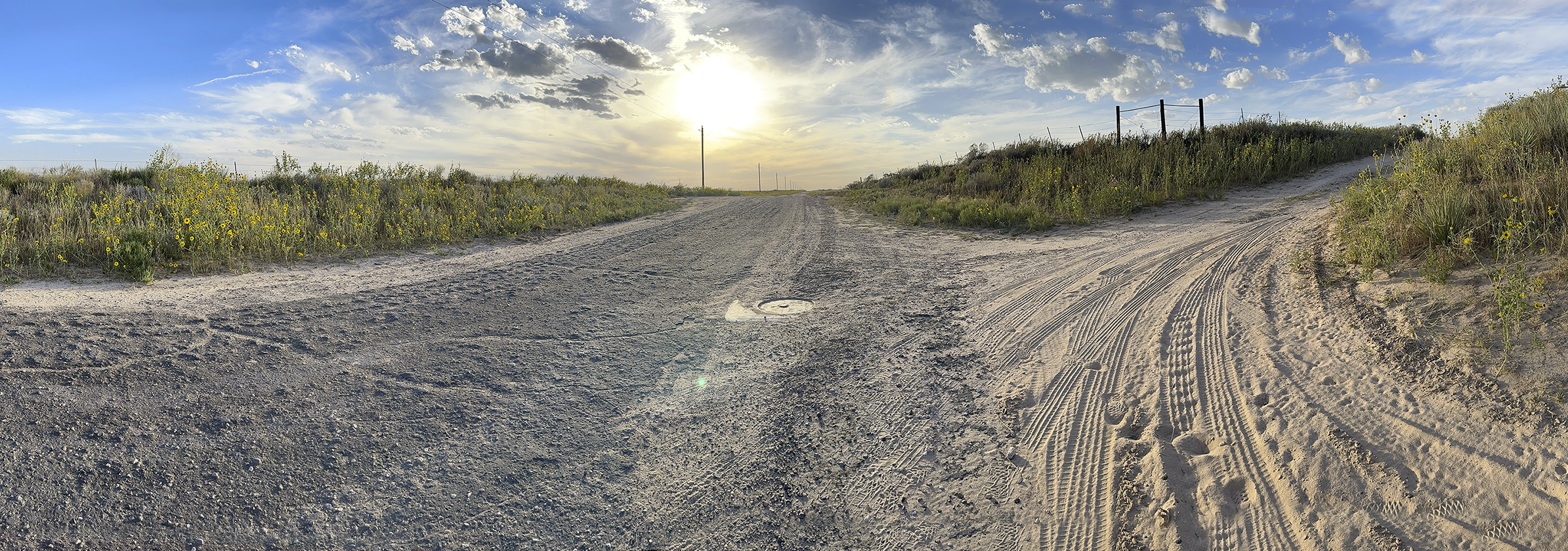
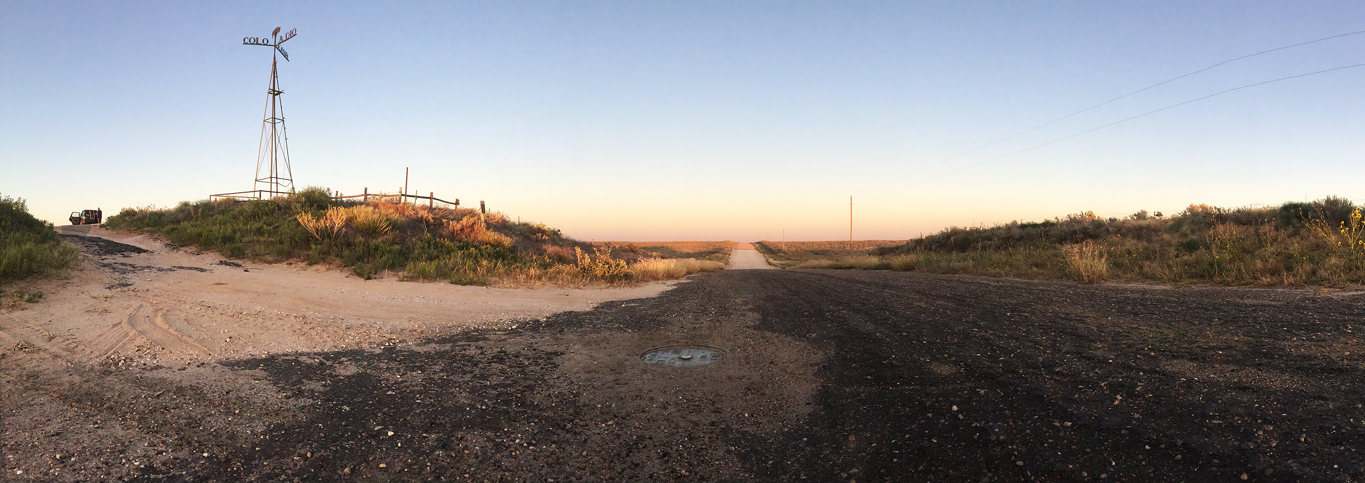
Back to the moment: we’re at Eight Mile Corner in the Cimarron National Grassland. A windpump tower was erected in 1903 with welded flags pointing to the three states. The tower disappeared sometime after September 2016.
This gently rolling sere landscape is completely devoid of trees; the shortgrass prairie looks tenuous– and it should. Eight Mile Corner was at the epicenter of the Dustbowl that began almost 90 years ago. Roughly four inches of topsoil blew away, coloring east coast sunsets orange; it’s estimated that 500 years would be required to build back an inch of topsoil, although the Union of Concerned Scientists has concluded that current farming practices continue to degrade the landscape– another half inch of topsoil is expected to be lost by 2035.2 This grim forecast has deep roots in agricultural hubris and climate misfortune.
The failure of stewardship goes back more than 100 years. In 1909 Congress attempted to revitalize the concept of homesteading by doubling the number of acres in a homestead claim to 320 acres in arid areas like eastern Colorado. But the amended law stipulated that homesteaders had to use dry farming methods in the same locations where the Colorado Agriculture Department antithetically advised new farmers to dig a well immediately since irrigation was required for a productive farm. Few of the “suitcase farmers” from Michigan and other eastern states who made homestead claims in eastern Colorado had sufficient capital to follow the Colorado Ag Department’s admonition that “there are many chances for [crop] failure…. It is safest to lay plans that will furnish a living with an average of two failures each five years.”3 When agricultural prices fell at the end of World War I, farmers increased acreage under tillage to make up for falling prices– an economic game of chicken. Farmers ignored the agricultural experts who warned that this land was never meant to be plowed. The Dust Bowl, then, was a conjunction of agricultural overreach and a climatologically extreme event.
Late September is the dry time of year here in the High Plains– we’d expect the grasses to fade into pale yellow dormancy. Still, the landscape’s survival remains in doubt– agriculture depends on water from an ebbing aquifer and the repeated application of fertilizers, like a double drug habit. Will this grassland survive, given the expectation of diminishing returns as wells dry up while temperatures rise? In late 2023 there’s strong evidence that denial runs deeper than water levels in the Ogallala Aquifer. Kansas’s Groundwater Management District 3, in the state’s southwest corner, is in the driest part of Kansas, with an aquifer in dramatic decline; it accounts for half of all groundwater extracted statewide. State officials and experts want farmers and other users to pump less, noting that other districts have reduced water use through more efficient irrigation techniques and new technology. So far, the leaders of District 3 have refused. Voting representation in Groundwater Management Districts is limited to large landowners, principally farmers and ranchers, a practice that excludes non-agricultural water users like cities and towns. Mark Rude, the water district’s executive director, defended restricting control of groundwater to large landowners. “It works pretty darn good for people that are invested in the land,” he said.4 When will the sand in which their heads are buried just blow away?
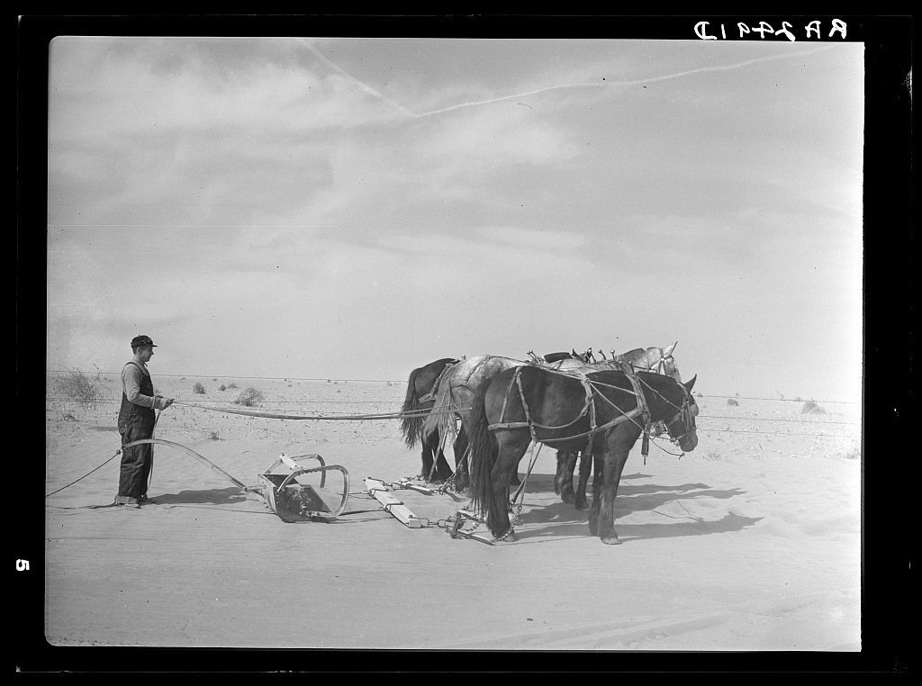
A number of Farm Security Administration photographs made near here documented the wind-driven erosion that devastated land and lives. Below, a scraper pulled by three horses clears soil blocking a highway 50 miles from the tri-state corner in 1938.
Now, a lifetime later, the land still suffers.
Footnotes
1. Richard Grant, “When the Socialist Revolution Came to Oklahoma—and Was Crushed”, Smithsonian Magazine, October 2019. https://www.smithsonianmag.com/history/socialist-revolution-oklahoma-crushed-green-corn-rebellion-180973073/
2. Union of Concerned Scientists, “National Soil Erosion Rates on Track to Repeat Dust Bowl-era Losses Eight Times Over”, https://www.ucsusa.org/about/news/national-soil-erosion-rates-track-repeat-dust-bowl-era-losses-eight-times-over
3. Amy Zimmer, “Time Machine Tuesday: Recovering from the Dust Bowl” Colorado Virtual Library, 5 November, 2019 https://www.coloradovirtuallibrary.org/resource-sharing/state-pubs-blog/time-machine-tuesday-recovering-from-the-dust-bowl/
4. Christopher Flavelle and Mira Rojanasakul, “As Groundwater Dwindles, Powerful Players Block Change,” NY Times 24 Nov 2023. https://www.nytimes.com/interactive/2023/11/24/climate/groundwater-levels.html
5. Farm Security Administration photograph by Arthur Rothstein, https://photogrammar.org/lightbox/photo/fsa1998018495/PP/state/OK/photographers/ArthurRothstein/themes/root%7CThe%20Land%7CFarms,%20Lands,%20Conditions%7CSoil%20Drifts
Next Location: westbound eastbound