Next Location: westbound eastbound
A parable of Tellurian Scripture
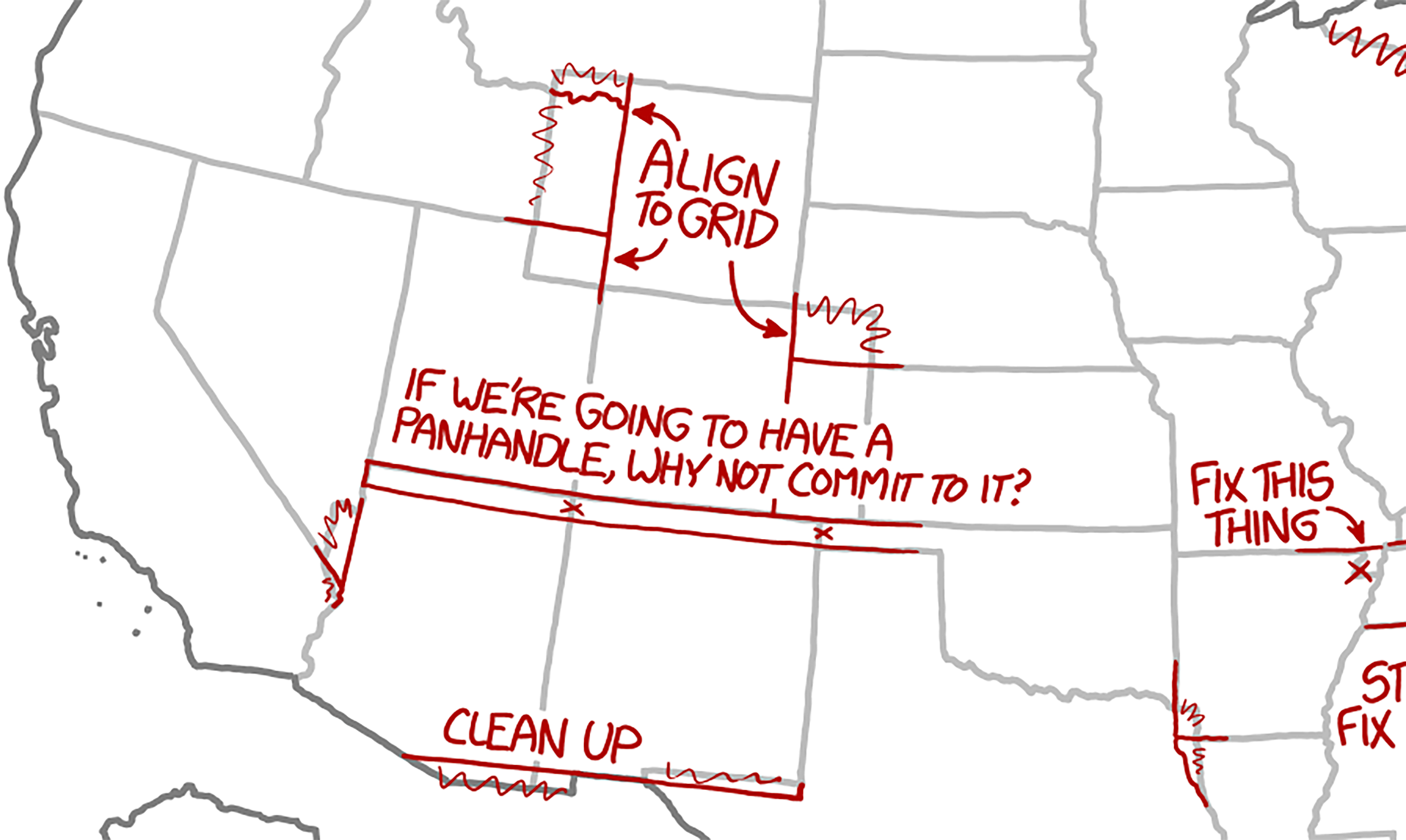
The corner marking the conjunction of Colorado, New Mexico, and Oklahoma could be the basis of a nineteenth century comedy of errors, or more likely, a horse opera. The southwest corner of Kansas was originally specified as reaching the 103rd meridian, the same line that separated New Mexico from Texas, a deal in which Senators horse-traded Texas debts for land in 1850. The dividing line between the territories of New Mexico and Colorado was drawn on the 37th parallel in 1861. Years later, surveyors out on the high plains struggled to find the imagined corner at the intersection of the 37th parallel and 103rd meridian that Senatorial cartographers back in Washington had dreamed up.1 Many mid-nineteenth century maps were drawn, imagining political boundaries that remained theoretical until they were staked in the ground: cartography’s strategic power had to be confirmed by a credible survey: Thomas Pynchon calls this “tellurian scripture” in his Mason & Dixon.2
Why the obsession with borders?
With the rapid takeover of the west came the governmental desire to impose order on a landscape that had managed perfectly well when Indigenous peoples had been in control; but now, Easterners sought hegemony in the west by establishing jurisdictions, enabling property ownership, and defining boundaries in the high plains. Cagey politicians— armed with fountain pens, straight edges, and a Machiavellian interest in preserving their own power— drew borderlines on the primitive maps of the far west.
This strategy of declaring power through cartography was implemented not only by American politicians but also by European imperialists around the world: In the mid-19th century, historian Marina Warner posits, “…border[s were seen] as a structural principle of civilization.”3 Before American interlopers arrived, the west was understood to be unsurveyed wilderness, which, says geographer Yi-Fu Tuan, “…signified chaos, the domain of demons…”4 to the devotees of the Jeffersonian grid. The Senators understood little of the “Great American Desert” as the high plains had been labeled by Zebulon Pike, and they cared little for its Indigenous inhabitants, but they correctly anticipated that territories would eventually become states, each sending two senators to Washington; if the West were segmented into small states, the eastern Senators would be outnumbered and lose their power; Thomas Hart Benton, Stephen A. Douglas, Henry Clay, Daniel Webster, and others were happy to draw straight lines denoting large territories on the maps which themselves were guesswork– a 1855 map labels the southeastern quadrant of Utah as “unknown.” The notion of cartographic power was at its height: the boundary lines on the maps were more important than the topographic information that underlay those geometric borders.
The Senators eventually ordered that their lines be transferred from paper to the landscape, of course, and surveyors were called in to mark borders across vast prairies and through snowcapped mountains. Little thought was given to how this task should be completed with accuracy. Let’s pause for a moment and consider the challenge facing mid-nineteenth century surveyors.
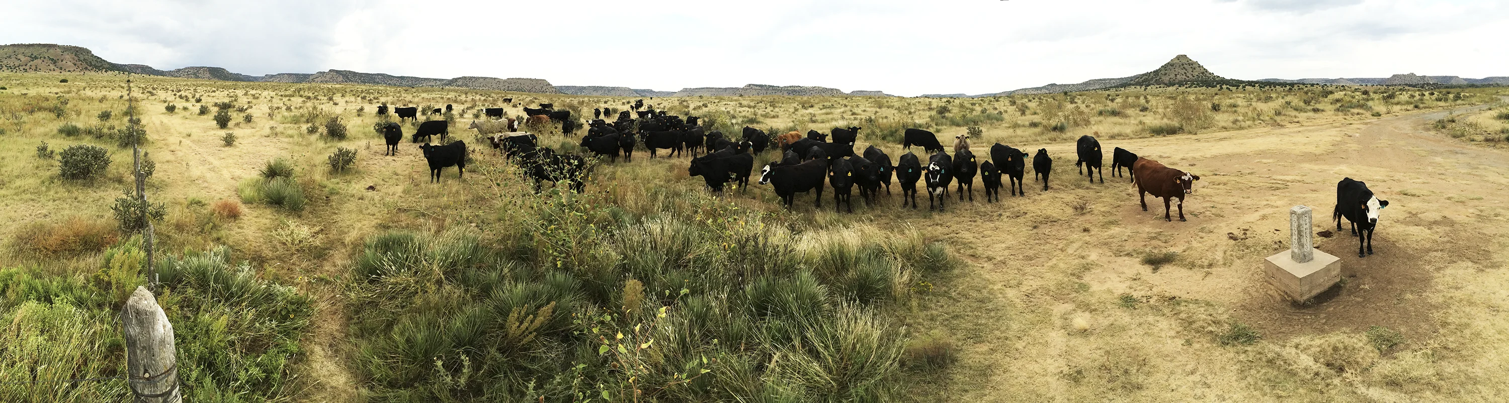
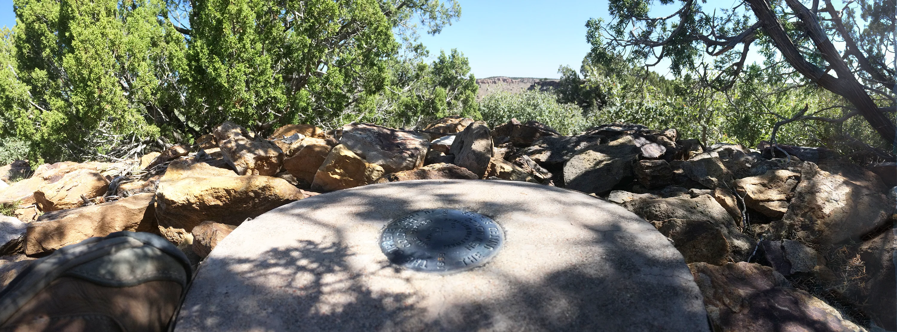
Surveying involves establishing north-south and east-west coordinates in order to precisely define any specific location— like the tri-state corner in the photograph above. Half of this task was relatively straightforward in the mid-nineteenth century: plodding astronomers, after several nights’ work, could establish correct latitudes if they could observe the stars, and surveyors had little problem heading due east or west along any latitude. Longitude, on the other hand, wasn’t easy to determine until the GPS revolution 150 years later, so nineteenth century surveyors relied on the surveyor’s chain to establish east-west coordinates. The problem started with the width of Kansas plus the no-man-land panhandle, which required J.E. Weysse’s chainmen to stretch a 66-foot chain 80 times per mile for 465 miles, across rolling hills and rivers with quicksand. The surveyor’s chain was thus pulled taut 37,200 times, and even small errors would accumulate. The survey of Kansas’ southern border suffered from an error of around two miles.5 It’s easy to see why the surveyors would want to verify that their measured border actually fell on 103˚ west longitude, the meridian agreed to back in Washington. Several attempts were made– like resurveying the relatively short distance from the Kansas border to New Mexico — but multiple surveys resulted in the establishment of competing corners. In 1868 Ehud Darling drew the Colorado-New Mexico border from one of them — Macomb’s 1859 monument– now recognized as sitting about 2 ½ miles west of the established corner.
Closing in on the Tri-State Corner
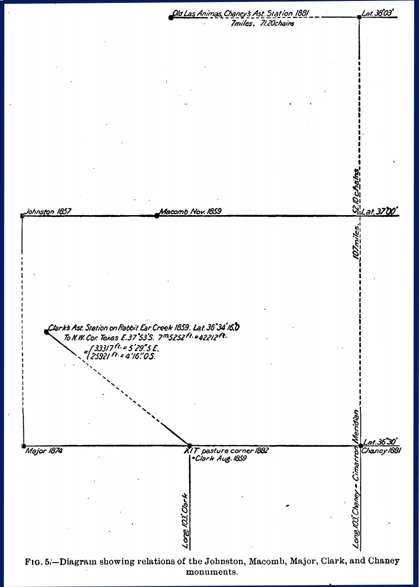
Repeated surveys failed to converge on an accepted location for the 103rd meridian. In 1859, two years after the initial survey of the southern border of Kansas, John Macomb attempted to establish the southwestern corner of Kansas at the location now recognized as the Colorado-New Mexico-Oklahoma corner— the Colorado-Kansas border is now 43 miles east of here. He missed by 2 ½ miles.
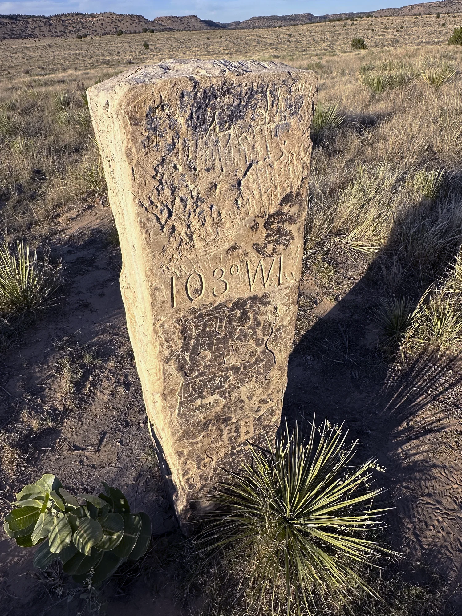
The Texas-New Mexico border, intended by Congress to lie on the 103rd meridian, was surveyed in 1859 by John H. Clark. Arthur D. Kidder retraced portions of Clark’s line and concluded that “the longitude is perhaps the most incorrect of any land line in the United States.” 6 In 1881 a major effort was made to resolve the disputes that affected not only Oklahoma but New Mexico and Texas boundaries as well. Surveyors Richard Chaney and William Smith trekked to Las Animas, Colorado and used a telegraph signal from Cincinnati to calculate the local meridian. They then proceeded to run a line due south 73 miles, 9 chains, and 42 links to the 37th parallel and established the Cimarron Meridian, the western border of the Oklahoma panhandle that ran south on the 103rd meridian to 36˚ 30′, the north boundary of the Texas panhandle.7
In spite of Chaney’s and Smith’s telegraphic heroics, the official corner is 681.5 feet west of the (astronomical) 103rd meridian. The gap between the abstraction of the Senatorial lines on paper and the high plains border markers persists to this day, and neither the maps nor the markers tell us anything about the land.8
In the end we find a thoroughly governmental way of describing the acceptance of surveyors’ ineptitude: “…ancient errors in the running and marking of a boundary line, which have been accepted and acted upon and acquiesced in by both parties, cannot be corrected.”9 The disconnect between the elegant ruled lines on Senatorial maps and the imprecision of the actual surveys would be forever ignored. Perhaps the only ones to fully appreciate the irony of self-inflicted imprecision: the Indigenous inhabitants for whom place is invariably more significant than boundary.
Nevertheless, cartography came to control the future of the west, at least from viewpoint of the U.S. government. Marina Warner argues, “Borders can install a new reality, as they make the past disappear. They have frequently been drawn arbitrarily, brokered between new or newish external powers…” [Warner points out that Europeans, especially the British, wielded cartographic power with impunity.] “[N]ew nations were ruled into the map of the whole African continent. Imperial mapping also controls naming, canceling in the process many local associations and historical memories.”10 This same process came to control the American West.
In the mid 19th century, drawing lines on paper was simple; redrawing them now could only be done by a cartoonist. Embedded in the joke below, though, is the implicit and enduring power of cartography to instruct us on how to think about the land.
“IT WAS SCARY WHEN THE GRAPHIC DESIGNERS SEIZED CONTROL OF THE COUNTRY, BUT IT TURNED OUT THEY JUST WANTED TO FIX SOME THINGS ABOUT THE STATE BORDERS THAT HAD ALWAYS BOTHERED THEM.”11
Additional survey note:
Now back to the 103rd meridian. New Mexico’s eastern boundary– with Oklahoma– is (approximately) on the 103rd meridian (also known as the Cimarron Meridian) only for ½ degree of latitude, from 36 ½º to 37º. The remaining 310 miles of the eastern border– with Texas– are between two and four miles west, thanks to John H. Clark who in 1859 located New Mexico’s southeast corner on longitude 103º 03’55”. The east-west difference of 2.17 miles between Clark’s line at 36º30’ and the Cimarron Meridian is called “Crawford’s Closure” and forms the little jog of our boundary west of the southwest corner of the Oklahoma Panhandle.12
——————————————————————————-
Footnotes
1. In 1859 John Macomb attempted to plant a marker for the southwestern corner of Kansas at 37˚ N, 103˚ West although his monument is 2 ½ miles west of the current corner. Senatorial cartographers drew the boundary between Texas and New Mexico Territory at 103˚ west longitude in 1850 and Colorado Territory’s eastern boundary (with Kansas) at 102°2’48″ west longitude in 1861. The 37˚ latitude line separating New Mexico and Colorado Territories was drawn in 1861.
2. Thomas Pynchon, Mason & Dixon: “”‘Hence as you imagine, we take a lively interest in this Line of yours,’ booms the Forge-keeper, ‘ inasmuch as it may be read, East to West, much as a Line of Text upon a Page of the sacred Torah,– a Tellurian Scripture, as some might say,—‘….” p. 487
3. Marina Warner, “No Freedom to Move” . New York Review of Books, 23 Nov 2023
4. Yi-Fu Tuan, Topophilia, p 63
5. Department of the Interior Bulletin of the United States Geological Survey No 194 Series F, Geography, 30 (Washington: Government Printing Office, 1902)
6. Ralph H. Brock, “Perhaps the Most Incorrect of Any Land Line in the United States”: Establishing the Texas-New Mexico Boundary along the 103rd Meridian. The Southwestern Historical Quarterly, Vol. 109, No. 4 (Apr., 2006), p. 451
7 Why, you might ask, wasn’t the Texas northern border set at the 37th parallel? The 1820 Missouri Compromise prohibited slavery north of 36˚ 30′ and Texans were willing to give up the territory in order to preserve slavery. The Texas border was finalized in the Compromise of 1850, establishing the undefined area now known as the Oklahoma panhandle.
8. Marcus Baker, The Northwest Boundary of Texas 1902
9. “A Communication Relating to the Boundary Line between New Mexico and Texas,” H. Doc. 1076 61st Cong., 3rd Sess (1910), (Serial 6069), 1-2; Act of June 20, 2010, ch 310, Statutes at Large of the United States of America, 1910, 36 (Washington, D.C.: Government Printing Office, 1910, 557 (New Mexco statehood enabling act). Quoted in Ralph H. Brock, op. cit. p 458.
10. Warner, op. cit.
11. Randall Munroe, xkcd–.A webcomic of romance, sarcasm, math, and language. https://xkcd.com/1902/ “State Borders”
12. Fred Roeder, LS, “Boundary of All These Kingdoms,” American Surveyor, 5 April 2009 https://amerisurv.com/2009/04/05/the-boundary-of-all-these-kingdoms/